


lac ferrand la fontauliere

raab
User
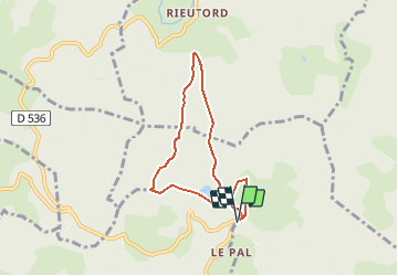

Length
6.4 km

Max alt
1321 m

Uphill gradient
241 m
Km-Effort
9.6 km

Min alt
1192 m

Downhill gradient
241 m
Boucle
Yes
Creation date :
2020-12-03 10:32:29.319
Updated on :
2020-12-03 10:33:18.753
--
Difficulty : Very easy

FREE GPS app for hiking
 SityTrail
IGN / Geographical institutes
SityTrail Plus
The world is yours!
About
Trail On foot of 6.4 km to be discovered at Auvergne-Rhône-Alpes, Ardèche, Le Roux. This trail is proposed by raab.
Positioning
Country:
France
Region :
Auvergne-Rhône-Alpes
Department/Province :
Ardèche
Municipality :
Le Roux
Location:
Unknown
Start:(Dec)
Start:(UTM)
592557 ; 4954675 (31T) N.
Comments